Space technology is often associated with rocket launches, astronauts and missions to distant planets. However, some of its most important contributions happen much closer to home. From checking the weather before travelling to using navigation apps, watching satellite television and receiving cyclone warnings, people interact with space-based technology more frequently than they realise.
In India, ISRO's satellite infrastructure supports communication, navigation, weather monitoring, disaster management and Earth observation. These systems do more than collect information from space; they convert it into services that support public infrastructure, businesses, government agencies and everyday activities.
Understanding this technology reveals an interesting reality: space exploration is not only about reaching beyond Earth; it is also about making life on Earth safer, better connected and more informed.
Key Highlights
- Weather forecasting: INSAT satellites provide meteorological observations that support weather monitoring and cyclone tracking.
- Navigation: India's NavIC system provides independent regional positioning, navigation and timing services.
- Agriculture and water management: Earth-observation satellites help monitor land, agriculture, forests and water resources.
- Disaster management: Satellite imagery supports flood mapping and the assessment of natural disasters.
- Fishing and ocean services: Satellite-derived information helps identify potential fishing zones along India's coastline.
- Communication: Satellite systems support television, telecommunications, broadcasting and connectivity in remote regions.
Why Do We Need Space Technology?
Modern societies depend on information that is difficult to collect through ground-based systems alone. Monitoring a cyclone over the ocean, observing changes across large agricultural regions or providing communication services to remote locations requires infrastructure that can operate over vast geographical areas.
Satellites address this challenge by observing Earth, transmitting signals and collecting information from orbit. Depending on their purpose, they can support communication, navigation, scientific research, weather monitoring and remote sensing.
ISRO's satellite programme covers several of these functions through dedicated satellite systems. Its communication satellites support broadcasting and telecommunications, while Earth-observation satellites collect data related to land, water, oceans and the atmosphere. Navigation satellites provide positioning and timing services.
Turning Satellite Data Into Useful Information
A satellite collecting information is only the beginning. Raw observations must be received, processed, interpreted and delivered to organisations or people who can use them.
For example, satellite imagery of a developing cyclone becomes useful when meteorological agencies analyse its movement and intensity and incorporate the information into forecasting systems. Similarly, images of agricultural land become valuable when experts process them to identify changes in vegetation, soil moisture or land use.
The real challenge is therefore not just putting satellites into orbit. It is building a complete system that converts space-based observations into reliable, accessible information.
Understanding the Core Technology
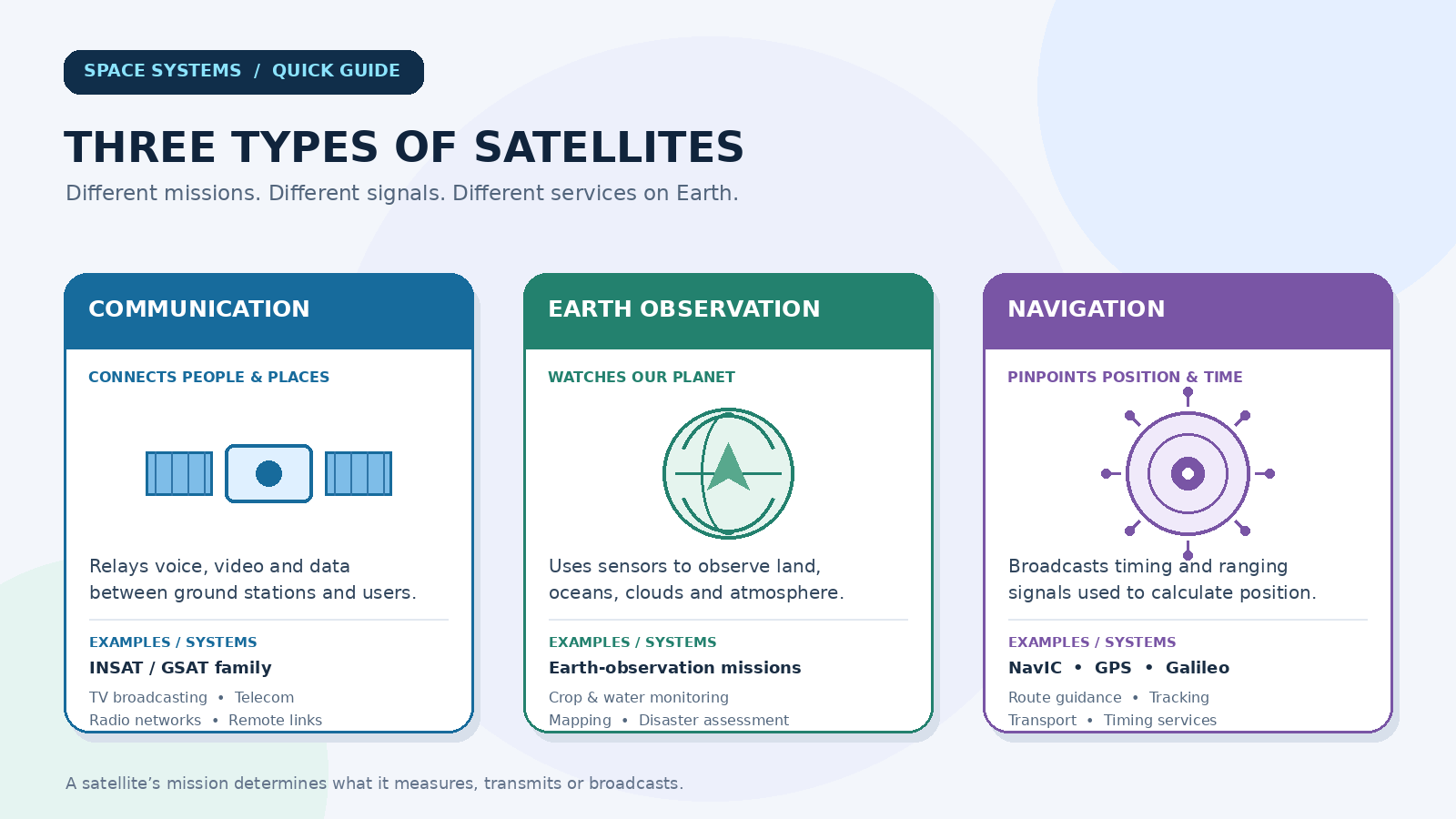
Space technology used in everyday applications can be broadly understood through three categories.
| Technology | Primary function | Everyday application |
|---|---|---|
| Communication satellites | Transmit voice, video and data signals | Television, broadcasting and remote connectivity |
| Earth-observation satellites | Collect information about Earth's surface and atmosphere | Agriculture, water management and disaster mapping |
| Navigation satellites | Provide positioning, navigation and timing signals | Location services, transport and tracking |
Knowledge Corner
- Remote sensing: Collecting information about an object or area without physically touching it, often through satellite sensors.
- GNSS: Global Navigation Satellite System, a general term covering satellite-based positioning systems such as GPS, Galileo, GLONASS and India's NavIC.
- Geostationary orbit: An orbit in which a satellite appears approximately stationary relative to a point on Earth's surface, making it useful for continuous regional observation and communication.
One important distinction is that GPS is not another name for every navigation system. It is a specific system operated by the United States, while NavIC is India's independent regional navigation system. Modern receivers may support signals from multiple satellite navigation constellations.
How Does the Satellite Technology Workflow Work?
Although individual satellite systems have different designs, most applications follow a common process:
Step 1 – Data collection: Satellite sensors capture observations of Earth, while communication and navigation satellites transmit their respective signals.
Step 2 – Ground reception: Ground stations receive the satellite data or signals required by the service.
Step 3 – Processing and analysis: The collected information is calibrated, processed and converted into usable data products, maps or navigation information.
Step 4 – Service delivery: The processed information reaches weather agencies, government departments, businesses, mobile applications and other users.
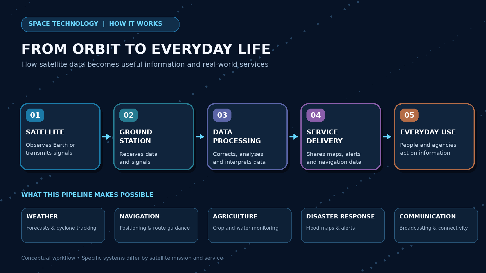
For example, ISRO's MOSDAC documentation describes the INSAT-3D data pipeline through ground reception, raw data generation, processing into calibrated and geographically located products, and final product generation and dissemination.
Where Does Space Technology Affect Daily Life?
Weather Forecasting and Cyclone Monitoring
Weather forecasting is one of the most visible applications of satellite technology. Meteorological satellites observe cloud patterns, atmospheric conditions, ocean temperatures and the movement of weather systems.
India's INSAT-3D and INSAT-3DS missions carry meteorological instruments designed for monitoring the Earth's surface and oceans, supporting weather forecasting and disaster warnings. The India Meteorological Department uses INSAT satellite observations to monitor weather systems, including tropical cyclones, and generate information for forecasting.
These observations help meteorologists assess developing weather conditions and provide information that can support decisions about travel, agriculture, public safety and disaster preparedness.
Navigation and Location-Based Services
Finding a destination, tracking a vehicle or determining the location of an object can involve signals from navigation satellites. A receiver calculates its position using the timing and ranging information received from multiple satellites.
India's NavIC (Navigation with Indian Constellation) provides an independent regional navigation capability. ISRO identifies applications including terrestrial, aerial and marine navigation, vehicle tracking, disaster management, fisheries and location-based services.
The system is particularly important because it provides India with an independent navigation infrastructure rather than relying entirely on foreign satellite systems. Its civilian positioning service is available within its designated coverage region.
Agriculture, Water Resources and Urban Planning
Satellite imagery allows experts to observe large areas that would be difficult to monitor entirely through ground surveys. The information can help identify land-use changes, monitor water bodies and support agricultural and environmental assessments.
ISRO provides Earth-observation data and related services for agriculture, forestry, mining, water management and rural and urban development. These applications are made available through platforms such as Bhuvan and Bhoonidhi.
For instance, satellite-based land-use information can support planning decisions, while observations of water bodies can help authorities understand changes in water availability.
Disaster Management and Public Safety
During floods, cyclones and landslides, authorities need information about affected regions to plan emergency responses. Satellite observations can provide a wide-area view of changing conditions and help map affected locations.
ISRO's Disaster Management Support programme uses space-based inputs for monitoring natural disasters, including floods, cyclones, landslides and forest fires. Its flood-monitoring activities include generating inundation maps for relevant government agencies.
India's NDMA also operates the SACHET National Disaster Alert Portal, which supports geographically targeted, multilingual early warnings through multiple communication channels. Satellite observations and public alert systems are different parts of the broader disaster-management ecosystem.
Communication, Education and Healthcare
Satellite communication is particularly useful where conventional terrestrial networks are difficult to establish or where additional connectivity is required.
ISRO's INSAT system supports television broadcasting, radio networking and telecommunications. Satellite links can also provide connectivity to remote regions and act as backup links for terrestrial networks.
Space technology has also supported social development programmes. ISRO's EDUSAT programme demonstrated satellite-based educational delivery through television broadcasts, video conferencing and web-based instruction. Its telemedicine pilot connected a hospital in Chennai with a rural hospital in Andhra Pradesh, demonstrating how satellite connectivity could support remote medical consultation.
How Satellites Help Fishermen Find Potential Fishing Zones
One of the more interesting applications of satellite technology in India comes from the fishing industry.
Locating fish in the ocean can require substantial time, fuel and effort. To address this challenge, the Indian National Centre for Ocean Information Services (INCOIS) uses satellite-derived ocean information to identify Potential Fishing Zones (PFZs).
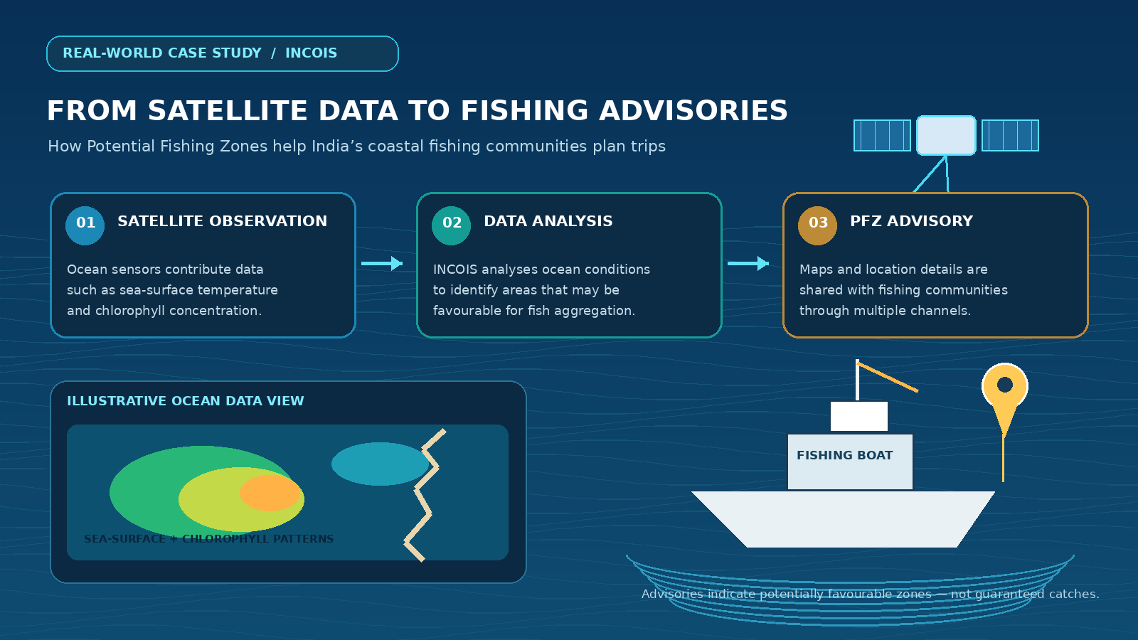
The system analyses parameters such as sea-surface temperature and chlorophyll concentration to identify areas that may be favourable for fish aggregation. INCOIS uses this information to issue fishing advisories, including maps and location details for coastal fishing communities.
According to the organisation, these advisories are provided daily with references to 586 fish landing centres along the Indian coast. They are also distributed through websites, mobile services, radio and electronic display boards, with information available in regional languages.
This is a practical example of space technology moving beyond scientific research and directly supporting livelihoods. Importantly, a potential fishing zone is an advisory, not a guarantee of a successful catch, because ocean conditions and fish distribution can change.
Benefits and Opportunities
The biggest advantage of satellite technology is its ability to provide information across large geographical areas. It can support services that would otherwise require extensive ground infrastructure or repeated manual observations.
Its impact can be seen in several areas:
Better decision-making: Satellite observations provide useful inputs for agriculture, infrastructure planning and weather forecasting.
Improved connectivity: Communication satellites support television, telecommunications and services in remote regions.
Public safety: Satellite-based observations can help authorities assess natural disasters and coordinate responses.
Economic support: Navigation, resource monitoring and fishing advisories can improve planning across different industries.
Scientific development: Satellite data creates opportunities for research in climate science, oceanography, environmental studies and geospatial technology.
For students, this also creates opportunities in fields such as remote sensing, GIS, satellite communications, geospatial analytics, aerospace engineering and Earth-system sciences.
Challenges and Limitations
Despite its benefits, satellite technology is not a perfect solution. Building, launching and maintaining satellite systems requires substantial investment, specialised infrastructure and technical expertise. The collected data also needs reliable ground systems and skilled professionals to process and interpret it.
Navigation services can face signal-related challenges. ISRO identifies factors such as atmospheric delays, satellite-clock errors, multipath effects and receiver measurement errors as sources that can affect positioning accuracy. Strong radio-frequency interference can also disrupt navigation signals.
Earth-observation information has its own limitations. Satellite imagery must be interpreted in context, and certain applications require ground-based observations for validation. Fishing-zone advisories also need regular updates because ocean conditions change over time.
The important lesson is that satellite systems are most effective when combined with ground infrastructure, scientific expertise and reliable communication networks.
Future Outlook: What Comes Next?
The next phase of space technology will increasingly focus on turning large volumes of satellite data into actionable information. Improvements in Earth observation, smaller satellites, advanced sensors, satellite-based connectivity and AI-assisted data analysis could expand applications across agriculture, environmental monitoring, transportation and disaster management.
For India, stronger integration between space infrastructure, research institutions, government services and private technology companies could create new opportunities for innovation.
Students interested in this field should look beyond traditional aerospace engineering. Remote sensing, geospatial data science, GIS, satellite communication, embedded systems and scientific computing are also relevant areas in which technical skills can be applied.
Conclusion
Space technology is no longer limited to rocket launches or scientific missions. Its applications extend into weather forecasting, communication, navigation, agriculture, disaster management and public services.
India's satellite infrastructure demonstrates how information collected hundreds or thousands of kilometres above Earth can support decisions and activities on the ground. The real achievement is not simply reaching orbit; it is making that technology useful to people.
The next time you check a weather forecast, follow a location on your phone or hear a cyclone warning, remember that the technology behind that information may have started far above the Earth's surface.